Blog / Vietnam
2025-05-24
How to tackle Vietnam’s amazing Ha Giang Loop
Along its narrow length, Vietnam offers an eye-opening variety of landscapes and natural beauty. And in the mountains of the far north, adventure beckons.
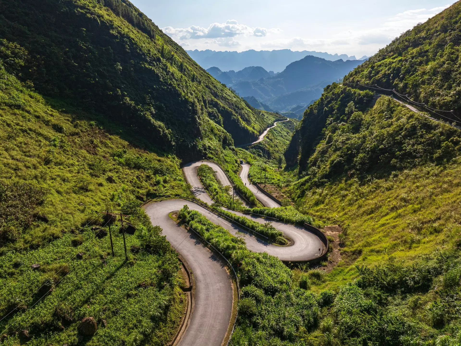
One of Vietnam’s superlative experiences, the famous Ha Giang Loop is a 370k road trip that circles through the Dong Van Karst Plateau in Ha Giang province, taking travelers to mountain passes in the clouds, through ethnic villages and over majestic rivers. (It will also probably be the best thing to happen to your Instagram feed in a while.) While it’s heavily traveled – perhaps too much so in some places – it nonetheless lives up the hype.
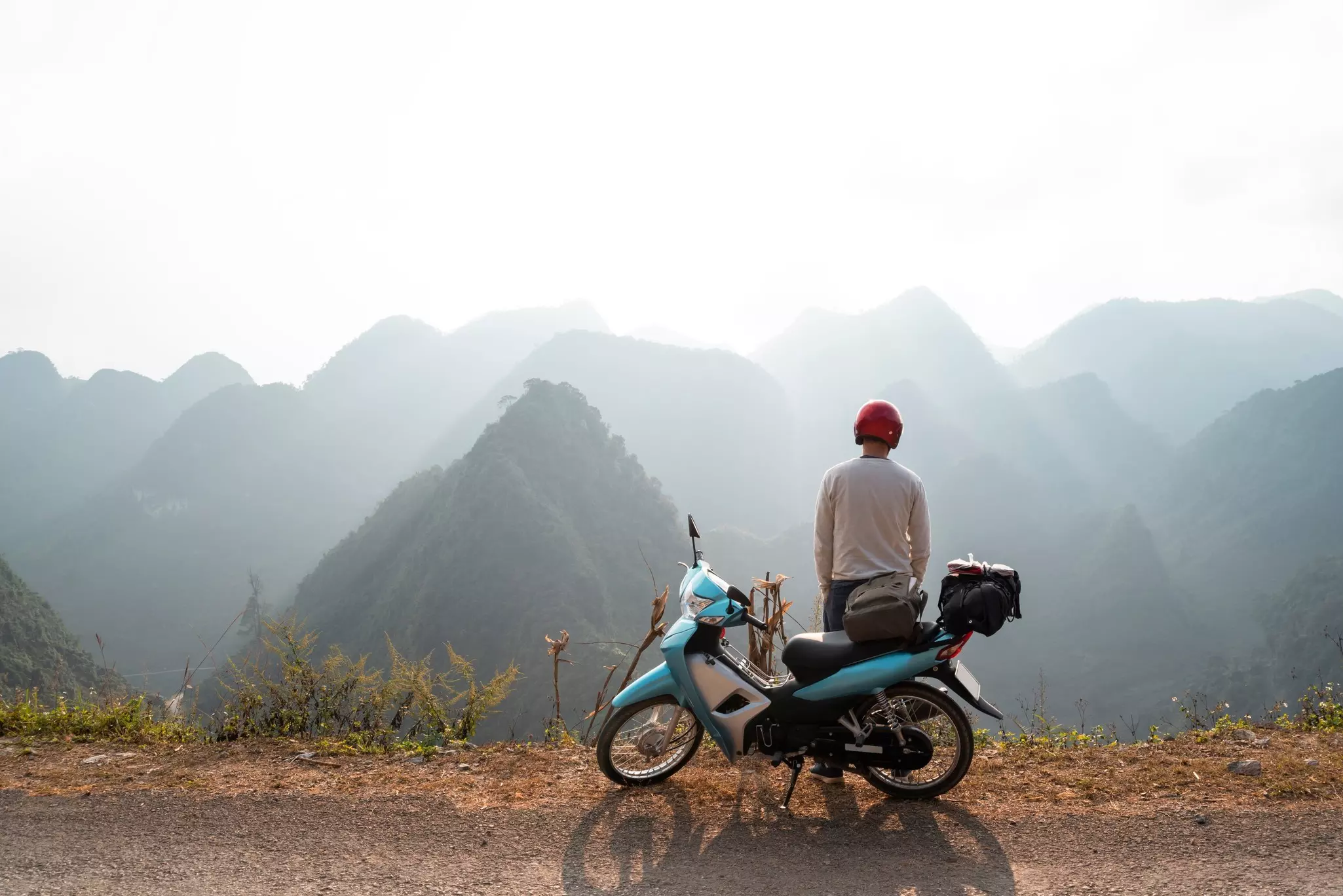
But before diving into Ha Giang’s landscapes and cultural treasures, there’s one essential tip to note: if you don’t have a Vietnamese or international motorcycle license, do not plan on driving the loop yourself. Jumping off the plane, renting a bike and getting behind the wheel without a license used to be possible (if arguably legal) – yet due to an increased police presence in Ha Giang (and fines that start at 2,000,000 Vietnamese dong) your best options are now to join a guided tour (you’ll ride on the back of the motorbike as a passenger) or hire a private car and driver. Such safe, all-inclusive tours allow you to focus on taking in the views.
As a longtime resident of Vietnam, I’ve had the pleasure of riding the loop twice. My recommended itinerary separates the loop into four main sections. (The most common loop duration is four days, though some travelers ride it in as few as 3 days or as many as 10.)
Note what stops and detours you’re interested in – then compare them with your guide’s recommendations. And happy riding.
- When to arrive: Most tour operators bring you into Ha Giang on a night bus or van from Hanoi, arriving at about 3am – which gives you just a few hours of sleep before the first day of action. If you’re not in a rush, consider arranging transport to arrive in the city a day in advance so you can start your loop adventure rested.
- How to get from the airport: Ha Giang is a 5-hour bus ride from the closest major airport (Noi Bai International in Hanoi). Few head directly to Ha Giang right after touching down, though. The most common way to get to Ha Giang involves a tour operator–arranged pickup from your accommodation in Hanoi’s Old Quarter. You can also arrange your own bus service through the booking platform 12Go.
- Getting around on the loop: Ultimately, there are three ways to travel on the loop: on the back of a motorbike as a passenger, at the controls of your own rental motorbike (if you have the right license) or by hiring a car and driver. While in Ha Giang City itself, it’s easy to get taxis or bike rides through the Grab app.
- Where to stay: If you’re passing through Yen Minh, consider spending the night at a Nam Dam Village homestay. Near Dong Van, the Lolo Village homestays are a good option. While passing through Meo Vac, look up Auberge de Veo Mac, a lovingly restored Hmong house with private rooms and dorms. Accommodation is factored into the price of any organized tour; if you’re traveling independently, expect rooms to run anywhere from $15 to $50 per night. Stay flexible, though: your guide may know of accommodations better suited to your route.
- What to pack: It’s very rainy from June to August, so bring spare changes of clothes, particularly socks and underwear. Between November and March, it gets quite cold at this altitiude: a heavy jacket, gloves and perhaps even thermal underwear will come in handy. Above all else, make sure you’ve got a good camera.
Leg 1: Ha Giang to Yen Minh
Approximate distance: 90km
Morning
The adventure begins. Since you’ll have a lot of ground to cover, plan on leaving Ha Giang city early. Head north on QL4C, and within half an hour you’ll start gaining elevation via the switchbacks of the 7km Bac Sum Pass. The road dips briefly before climbing again through the towering Quan Ba Pass (Heaven Gate). Keep an eye out for the lookalike Twin Mountains on the way. Plan for a coffee break and selfie session at the grand lookout spot at Cafe Cong Troi.
Afternoon
There are two worthy sights near Heaven Gate (if you’re trying to reach Yen Minh by the end of the day, it’s best to choose just one). From Heaven Gate, you can drive 30 minutes over to Lung Khuy Cave, a hushed, ancient cavern with a raised walkway and a few small altars. You can also go down the stairs near the cave’s exit and take a dip in a hidden pool. Accessing the cave requires a steep 20-minute hike from the parking area, so we wouldn’t recommend this if the weather is very hot or rainy.
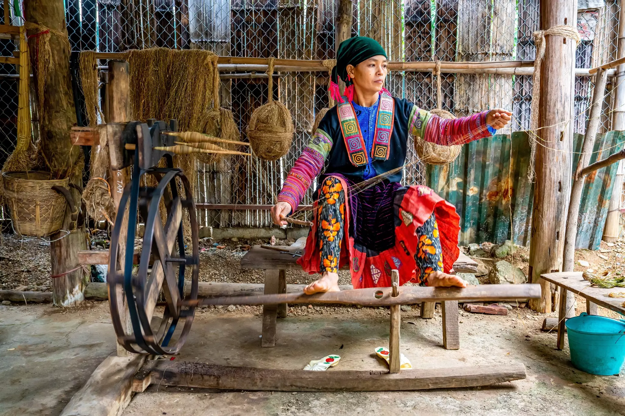
A lengthier detour involves driving 50 minutes (via QL4C and DT181) to reach the Lung Tam Weaving Village, where you’ll find a courtyard and hut where Hmong women weave and embroider linen textiles by hand. While you can find these goods in shops throughout Vietnam, purchasing them close to where they’re made helps the artisans more directly.
Evening
Yen Minh Town is a good spot to end the first day on the road. You don’t need to look far for dinner: here and throughout the loop, you’ll usually eat dinner at your village homestay accommodation – unless your guide has a specific restaurant suggestion.
Best detour
Nam Dam Village, only about 8km from Heaven Gate, is a lush Dzao settlement with a waterfall nearby. It’s a great alternate overnight spot if you’re not in a rush to make it to Yen Minh on the first day.
Leg 2: Yen Minh to Dong Van
Approximate distance: 100km
Morning
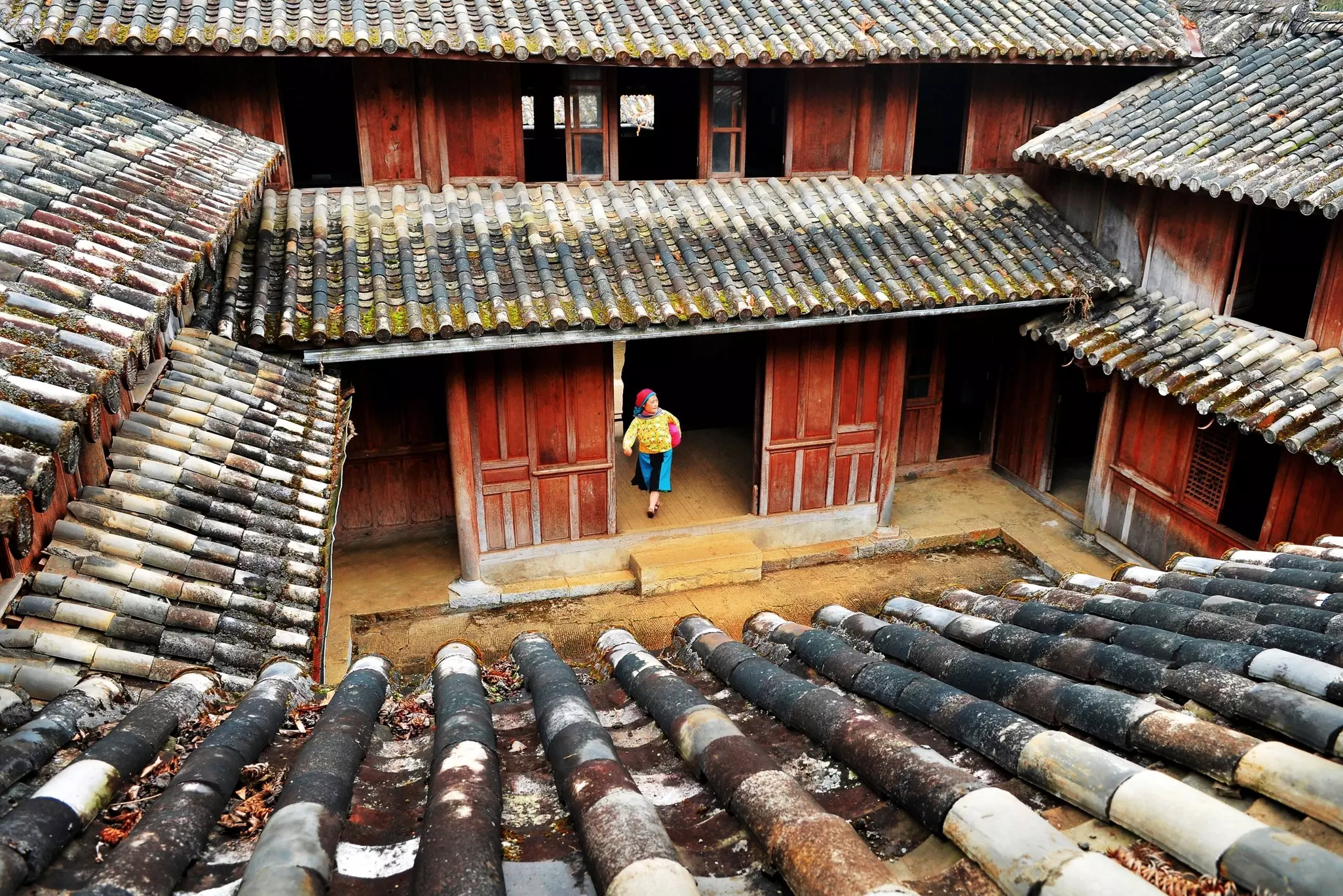
Today’s ride brings you to the northernmost point of Vietnam. Leave Yen Minh early for the 45km drive to the Dinh Vua Meo (Vuong Palace), a Chinese-Hmong structure built by the French for a local king in the 1920s. The faded photographs of the king and his family on the palace’s walls give you a glimpse of a prior era of Vietnamese history. Grab a coffee or souvenir from the shops in the parking area, then saddle back up for the next 29km push to the mighty Lung Cu Flag Tower on the Chinese border. It’s almost 400 steps to the base, and another 140 inside the structure to reach the top of the 30m tower – and the view is worth the climb.
Afternoon
Two local villages merit some time today. Many guides recommend visiting Lolo Chai, a quiet village of earthen houses not far from the flag tower; it’s great to experience during festivals. The other is Pho Bang, a rare Hoa (ethnic Chinese) village, mostly unspoiled by the excesses of the Ha Giang tourism machine. To visit the latter one you’ll need to rearrange your schedule, as it’s closer to Yen Minh.
Evening
Aim to reach the mountain town of Dong Van (26km from Lung Cu) before sunset to leave yourself enough time to stroll the cobblestones in the Old Town section. There’s also a colorful Sunday market if you’re passing through at the right time. Have dinner at the Ethnic House Lounge Bar & Hostel, a reliable inn for weary travelers that serves some Western and traditional Vietnamese dishes. A few doors down, Phien serves excellent coffees and cocktails.
Best detour
A short, steep path just north of the Old Town brings you up to the French Fort, a crumbling observation tower giving a hawk’s-eye view of Dong Van and beyond. It’s best visited at sunset after a long day on the road – or at sunrise, before the next day’s drive starts.
Leg 3: Dong Van to Du Gia
Approximate distance: 100km
Morning
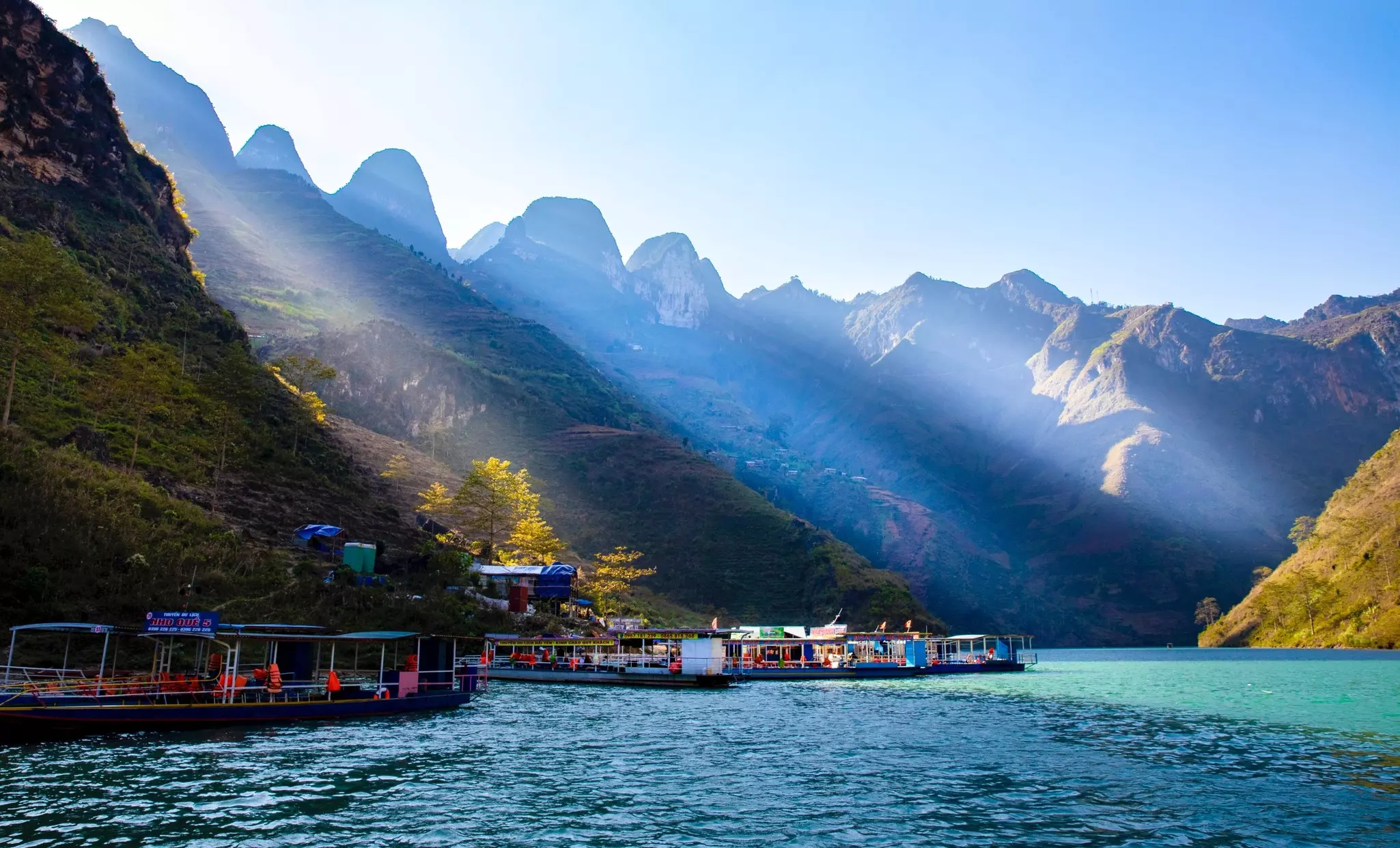
Start today’s adventure by trading in the bike for a boat. Head 5km from Dong Van to Ta Lang Harbor for a cruise up the emerald-green Nho Que River, which will give you a look up at Ha Giang’s towering karsts from the water. (You can also take a river cruise from the dock at Xin Cai later in the day, after going through the Ma Pi Leng Pass – ask your guide which river tour they recommend.)
Once you’re back ashore, continue on QL4C to the Bao Tang Con Duong Hanh Phuc (Happiness Road Museum). Also called the Youth Volunteers Monument, the site commemorates those who perished building Ha Giang’s mountain roads. There’s a parking area directly next to the monument for the Sky Path hike, a gorgeous walk that gives you a chance to stretch your legs for a while.
You can do the entire 90-minute hike, which gains a few hundred meters in elevation on its way to the White Cliff and Tu San viewpoints. Or you can take a shorter route and just walk up to the first major viewpoint – a craggy summit (Mom Da Tu Than) that has one of the best photo opps of the loop – before heading back to your bike.
Afternoon
Next, it’s time to hit the Ma Pi Leng Pass, one of the most famous sections of the loop – a jaw-dropping 20km ride that threads between limestone towers and through twisty switchbacks. From there it’s about 80km to Du Gia, a valley that’s home to over a dozen ethnic groups. Stop on the way for coffee or beer at one of the many cliffside viewpoints.
Evening
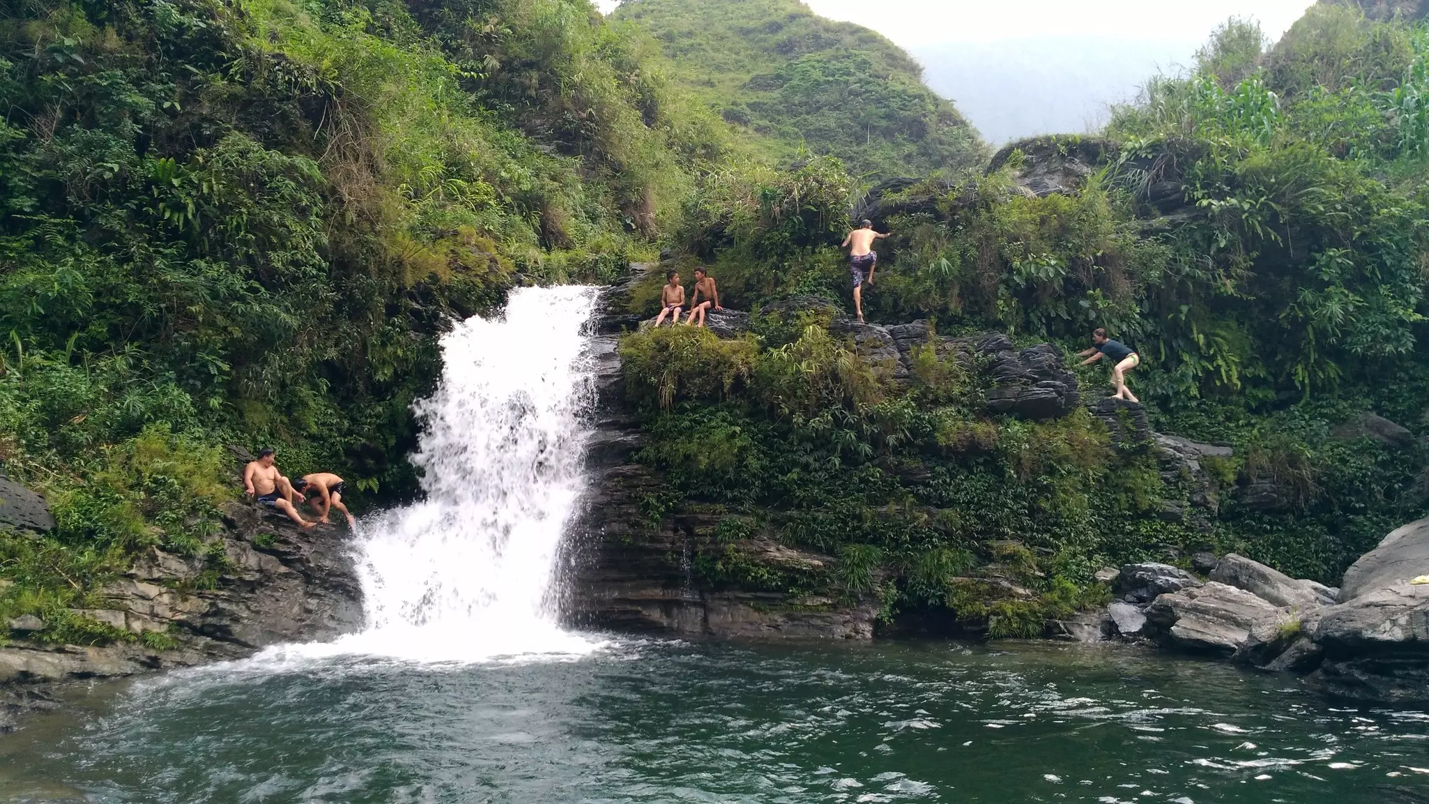
Pull into Du Gia Valley for a well-needed rest. (Those on group tours should be ready for this to be a rowdy evening – with plenty of rice wine – as it’s the last one before returning to Ha Giang the next day.) If you arrive before sundown, take a short 5-minute ride over to Du Gia Waterfall, just outside of the main village. This lush swimming hole is a pleasant place for a sundowner – though it can sometimes get overcrowded by tour groups with boom boxes (you can’t win ’em all).
Best detour
Consider staying in the charming market town of Meo Vac (just 15km from the Ma Pi Leng Pass) overnight if you’re taking a few extra days on the loop.
Leg 4: Du Gia to Ha Giang
Approximate distance: 85km
Morning
Since the villages along the loop route are often overlooked as merely overnight rest stops, consider a morning stroll through Du Gia’s idyllic rice terraces. Then roll out of town northeast on DT176 toward Viewpoint Lung Ho – a serviceable roadside cafe set with a few small karsts you can climb on for photos that’s only 10km from Du Gia. Then push on toward A Boong Waterfall. It’s about 40km from the viewpoint at Lung Ho, and though it’s not as gorgeous as Du Gia’s waterfall, it’s usually quiet and good for a quick dip.
Best detour
Di Tich Don Phap (French Fortress), a stone fort left behind by the French that’s nice for a quick wander. Find it near the junction of DT176 and DT181.
Afternoon
With most of the loop now behind you, it’s time to bring it home. After leaving the A Boong Waterfall, connect with the QL4C for the 35km drive back to Ha Giang. Unless your guide has any detour recommendations, this will probably be the shortest day of your loop adventure, and you’ll be back in Ha Giang for a celebratory beer at Top of the Loop by late afternoon.
If you have some time, linger in Ha Giang itself before setting off for your next destination. As with any other transit hub, the city doesn’t get much attention, but it’s quite pleasant. There’s a great walking area along the Lo River with cafes built over the water on concrete poles. There’s also a monument on D Nguyen Trai: marked “0 KM, ” it serves as the “official” start and end point of the loop, and makes for an excellent photo stop. Look for the statue of Uncle Ho in the square across from the street.
It’s not possible to experience the full wealth of Ha Giang’s experiences on one tour. Yet if you’re like most travelers, your first loop ride will surely inspire you to return for another one.